September means another trip to Mt Isa and this time I am taking my mate Peter Locke, Pete is the one who originally told me about Rosebud and the tunnel and being a man born and bred in the area he has a lot of local knowledge.
 |
| First stop |
So a 6 O'clock start and off to our first stop Charters Towers for breakfast.
Yes I know that Mackas is not the breakfast that you would associate with a trip to explore the wild west but what the heck the last fast food for 700k and its quick.
Breakfast out of the way we head off to Hughenden about 250k away, now Peter is a bit like me in as much as he likes to know what is down that road the difference out here is that Pete has been down most of them, so as we were leaving Hughenden Pete asked the question
 |
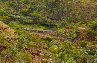
| The jump up |
"have you been to Richmond on the old highway" with my answer in the negative we turn right as we pass the roadhouse on the hill and head off down the dirt to Richmond.
Even though the road is gravel in places it is better than the main road, my mate Pete used to drive road trains out here delivering fuel to the cattle and sheep stations, a pretty tough job especially in the wet season, Peter was telling me that one of the reasons for changing the road was that at the Richmond end there was a jump up that when it rained made it almost impossible for trucks to use the road, now a jump up is a section of road where it climbs over a short distance.
This particular piece of road jumps up about 100mtrs over about 600mtrs, Pete tells me that the top used to be about 2mtrs higher before they put some bitumen down to give the trucks a fair chance in the wet.
 |
| Old shearing shed |
We continued to follow the road and dropped down on to the flat and about 15Klm up the road encountered our first problem, the property owner has closed the road through his land and there was no way around, so back we went.
 |
| Old Gidgee fence |
We had passed a property with an old shearing shed near the road and as we got to the road leading to it we met up with the property owner, he told us that in the past some tourists that found the road and had upset the owner of the land that the road passed through so now it was closed to everyone, apparently the owner is hard to get along with and is cantankerous and easily upset, he also said that there was another way around so after having a look at the old sheep property we set of to Richmond via another property, Peter told me once about a property that he used to deliver fuel to where the owner used to ride around with a pair of 45caliber pistols strapped on and an old Winchester lever action in a scabbard this is the guy that owned the cattle station that we could not pass, the guy that gave us directions confirmed that this was so (story Pete 101 confirmed).
 |
| Gidgee way (road to Mckinlay) |
After fueling up in Richmond we set out for Julia Creek, the road out here is pretty terrible the black soil around the Channel country is not a good base for road building and as much as the Government promises to fix the problem roads they only do enough to look like they are acting, about 9 months ago they started road works between Richmond and Julia Creek it is still not complete just one lane for about 15Klm and by the time its finished half of it will have pot holes in it.
Past Julia Creek we turn on to the Gidgee way, there used to be a great old pub down here, just a few posts remain I think that next trip I might spend the night here to explore, this is a dirt road but smooth you can realy get along here no traffic and better than the bitumen.
Out here you really get a sense of how vast this country is even with nothing to see this is still a beautiful place, in the photo above there is one tree in the distance but this was a heavily timbered area in the early pioneer days, the main timber here was Gidgee a very hard wood excellent for building fences and one of the best firewood's around and also the trees competed with the grass for water that was needed for the sheep.
We were on our way to Percoil Station a very large cattle property that "yes" Peter used to deliver fuel to, this was a sales call as Pete knows the owners, on the way down the station road we passed a turn off to another property, Pete says as we pass, this is probably the only place you will go to the local rubbish tip and find a Super King Air in the rubbish "yea of course" but an incredible coincidence! at the same time as we were there our sales rep in Townsville was talking to a chap who owns a air charter called West Wing, and he was the pilot of the plane, he was landing on the airstrip on his property and clipped the top of his wife's Land cruiser and flipped it sustaining very serious injuries (Story Pete 130 confirmed ) hmm I think there is a book here somewhere.
 |
| The camp site |
Well onto Cloncurry and to a place Peter knows where we can camp, just as well as we have traveled about 750Klm and it is getting dark.
About 7:30 Pm we set up camp and cook our tucker, now apparently this place has been put on a camper van web site so there were a couple of 4x4 caravans there as well big flash set ups so a couple of old guys rolling out their swags on the creek bank has the curtains fluttering.
 |
| First camp |
The next morning as we were cooking breakfast a couple of the men came over to sticky beak and have a chat before long there were about six men and women listening to stories no's 150 to 190 about western Queensland, road trains and the dangers of traveling in the west.
Story 178 "Pete" did you see the cans embedded in in the clay wall at the intersection of the highway and the beef road to Georgetown, "audience" no what happened "Pete" (long story short) these two brothers were travelling from Georgetown to the Curry drinking rum and coke in cans they had drank over a carton and pulled up at the pub and got some more, when crossing the bridge at the intersection they clipped the guard rail and rolled end for end, the car hit the clay wall so hard that the rum cans embedded in the wall, "audience" how long ago was that "Pete" about 10 years "audience" that was terrible " Pete" as he was getting in the car Yep true story I still stop every now and then and dig one out and have a drink just to remember them.
 |
| Rosebud Gums |
We did the sales calls in the Isa next day and then after a night in a comfy Motel we set off to Rosebud, this time we had a detailed map of the area but still went in through Mt Frosty, the road looked like it had been graded, but just enough so the property owner could get some road trains in to ship cattle.
We pushed on a fair way before stopping as we had a early start and both of us had seen Mt Frosty and the gorge before.
 |
| Lion rock |
We were having a bit of a look around when we saw this rock that looked like a lions head so I decided to get a photo of it, after I had got the shot that I wanted, Pete said that he wanted to get a photo of him with the rock I was walking towards the rock watching my step when Peter yells out hurry up this thing is sharp, I looked up and he had stradeled the rock, he is now known as Planking Pete.
While we were organising planking Pete we spotted a pipe coming out of the ground on a ridge so we decided to walk up the hill to see why it was there, the only explanation obvious was that it was a vent for an old
mine shaft, so we had a bit of an explore and found an abandoned mine that had probably been reopened a couple of times and showed signs of recent work.
 |
| Open shaft |

There are many old mine shafts around here some are not easy to see so a lot of care is needed, Plankin Pete and I had a good look around for hidden shafts so that we did not accidentally fall in one, when we were confident that we new where they were we took time to explore the diggings and shafts. The other shafts that looked a bit more modern may be 40-50 years old were still in a dangerous condition and some care has to be taken, even though it looks like someone has been going down one of them.
There are some structures of sorts and probably from the last 50 or so years, one looks like it is used by prospectors or campers and a couple of old buildings to house winches to lift ore from the shafts.
There is an outside dunny with a solid steel toilet seat in fact the whole toilet is made of steel,tough but would be a bit cold in winter and you would not want to leave the door open in the summer and have the sun on it.
 |
| lean to at the mine head |
We spent about an hour at the mine site but had to move on, you have to plan to come back here many times to see all there is to see every where you look there is something interesting caves in the mountains, rock formations and just the country itself.
 |
| The Dunny |
There are so many different rock formations that you have to imagine this was a very active area when the country was formed it is not hard to imagine the Dinosaur's that they are finding around Cloncurry and Richmond hunting in this area.
 |
| Ancient rock |
 |
| Caves in the hills |
Or may be in more recent times before the miners came the Aboriginal tribes hunting and using the many caves in the area for shelter. By the time we had finished at the old mine and exploring the rocks we were starting to run behind time and we had not even got near where Mike and I had reached previously.
 |
| Road to the mountain |
We arrived at the place that the map indicated for the Maltese crosses, so we had a look around but could not see anything like what we thought they should look like, so we dug around and found some stones that looked interesting which we have since found out were what we were looking for anyway.
 |
| Nearing Destination |
From here on the road started to get interesting and we were starting to select 4x4 regularly.
We were starting to get to where Mike and I turned back last time and I was hoping that the new Cooper tires and the 40mm that I had raised the Mitsubishi would be enough to get up the fairly extreme rocky climb ahead.
 |
| First of the rock |
 |
| First jump up |
We arrived at the WeeMacGregor mine after the first of the really rocky bit of track, after a bit of a look at the mine not to much as it was now the middle of the day and fairly hot we tackled the next bit to get to where Mike and I called it Quits.
Once we had got to the top of the first jump up we saw the stone pitched wall that Mike and I had seen when we turned around, as it turned out we were directly below the Tunnel that we came so far to see.
 |
| Stone pitched wall |
This wall is part of a road that was built for the rail line through the tunnel it was made from the rock dug out when the tunnel was made.
Now that we had got to this point we decided to walk the next section as now we had got to a bit of track that could hurt you if one was not careful.
We new from our map that we were not far away and real'y wanted to get to the top of the range and it was by now after 2 O'clock, we both walked up to the top and on the way found that when the road had been cut in to the mountain an old mine shaft had been revealed, this had been sealed but someone had wanted to see inside so the steel door had been ripped off, to give a bit of perspective to how to how the miners in this era worked
 |
| The open shaft |
 |
| Pete walks the jump up |
I took the photo of the open shaft kneeling down and I could not have entered the shaft except on my hands and knees.
 |
| Hands and knees shot in to shaft |
 |
| Last of the climb yes this is the road |
The next part of the climb was just slow 4x4 and careful placement of the vehicle because of the incline and the sharp rocks, we had walked this bit and knew that when we topped this rise we were at the top.
When we finally reached the top we got out the map to see where the road leading off to the tunnel was, we had two choices a road that was supposedly where we were, or one at point 4 of a Klm further on.
As it happens when the road was cut in to the mountain it was lowered by about 2mtrs so the top road was out so we headed down the other side to the other road.
We did not walk this next part, probably should have because the next point 4Klm made the last5Klm look like a drive on a Brisbane freeway.
 |
| Highville tunnel |
Having reached the turn off to our destination we stopped to look at small stone pitched wall that looks like it was a loading ramp and at this point it looks like we might be on the old railway line, we follow this track for about 800mtrs and then there is our destination.
 |
| Tunnel entrance |
The tunnel is known as the Highville tunnel Highville is the abandoned town just a bit further on the track I believe that it was constructed in 1913 and was part of the small gauge (2 foot) rail line from Ballara which is another small abandoned town further on to the Wee MacGregor mine, the tunnel is included in the National Heritage listings, it is also the only railway tunnel in western Queensland , near the entrance to the tunnel is an area that you can park your vehicle and enough space to camp, looking out from the park you look down on to the old rail line and old rail structures it would be a great view early in the morning.
 |
| No frills tunnel |
Now I know that many people have been here before but after trying to get to this spot three times I feel like We have discovered something, I have looked briefly in to the history of this place and you really get a feeling that this is an historical place the men and I suppose women that worked and explored this area were special In as much as this is tough country and in the late 1800s and early 1900s it was wild and remote they came from many different countries and seemed to have no problems living together.
There is a colony of rare and endangered Bats here the Troughton's Sheathtail Bat, a very tiny creature and this is the the only area that they are found, these bats are on the critically endangered list.
You would think that being a train tunnel that it would be bigger,
 |
| Troughton's Sheathtail Ba |
you could get a small vehicle in here but this is a no frills tunnel there is only about a meter of head room and very narrow, the locos must have had just enough room to pass through.
When you think about it and imagine what tools that the miners had in 1913, no modern drilling rigs and sophisticated explosives this would have been hard yakka digging through the rock and good solid rock it is to.
While we were walking through we could hear what I thought were wasps but we could not see any this went on all the way through, we were looking at what we thought were wasp nests on the wall and then Pete saw the insect that made them, these were native Bee nests and if you chipped a bit away there was honey in them the Bats and the Bees seem to cohabit just fine so after getting a couple of pics we left them alone.
You can still see after all these years the black soot on the roof and when you get to the other side the views are just awesome over the mountains stretching north and down to the Wee MacGregor Mine.
The last time when I came with Mike we met some people filming for National Geographic and they said that they saw us on the road now I can see what they meant, Mike and I were at the old mine when we decided to go back, from up here Peter and I could see how big this old mine was.
the mine started in 1910 and produced up until about 1920 the main ore was Copper and in its lifetime the mine produced over 36,000 tonnes of copper ore, that mean that
 |
| Abandoned Wee MacGregor mine |
for the first 3 years before the rail line was built the ore was taken out by road.
I suppose that meant back towards Cloncurry through Ballara but even today this is a very tough track.
Looking back down to the old mine you can see it was quite large there is a dam and extensive workings going back in to the hills, it is down in a valley and when Peter and I were there, even though this is still a cool month, we did not stay around because of the heat, it would have been a hot place to work in the summer as in the Isa the Temperature often gets in to the 40s in this valley with no breeze it would have been stifling and I bet these miners did not get $100,000.0 plus to work here.
 |
| Wee MacGregor entrance |
We have had a good look around for this trip and have to get back to our camp site from the first night and we still have to find our way out.
 |
| The Bats |
Looking back to the Wee MacGregor entrance to the tunnel I am still in awe of the people that constructed this and the rail line that goes back through this tough country to Ballara.
So we head back out to the car and say goodbye to the Bats and Bees, I am already thinking about the next time I am out here again.
The road out follows the old rail line and in so many places you can stop and see old bridge works concrete piers and supports for the line to get over the many creeks and gullies, now concrete was not a new thing in 1913 but there were no modern batching plants and concrete trucks to cart it around so I suppose that the workers would have to mix it up onsite and just keep going until the job was done, I once helped a mate lay a concrete slab in the bush using a concrete mixer and just mixing and pouring until the the job was done, these concrete bridge supports that are on this line make that job look mundane, Ill say it again tough men.
 |
| Hightville cemetry |
Our next stop on the way out is Hightville where a lot of the miners lived, it was also established in 1913 although there was the MacGregor hotel and Post office as early as 1909, there was a school that catered for children from Ballara as well as Hightville, now Ballara is about 4Klm by road so it would have been a bit of a rough trip to school for the Ballara Kids.
There are still 5 graves that can still be identified but probably many more that have not been found, the road passes through the site of the MacGregor hotel and then on to Ballara, on this road which appears to be the old rail line are many remains of bridges and you can almost hear the little loco in the bush that used to service the mine.
 |
| Change over loading platform |
 |
| Old rail bridge |
About 3.5 Klm along this road we came to a loading platform where they used to transfer the ore from the small line to the standard 3'6" line.
Next stop is Ballara and the junction of a couple of roads, the highway, Fountain springs and the road down to China Wall, but its getting on we have been on this road for about 7hrs and we are hot and need to stop for a while, I take a couple of photos of the old railway station and we are off to Clem Walton Park where we camped on the first night.
From here on the road is pretty good in places we get up to 80Kph and now I am getting thirsty as well as hungry we have been so engrossed in this place we have not had any thing to eat since breakfast.
We get to the camp and a couple of the travelers are still there
 |
| Getting the dust off |
and are interested in our adventure as Plankin Pete had told them where we were planning on going, but first things first on with the shorts and in the creek to get the dust and sweat off, now Peter does not drink alcohol any more but I had a few stashed in the fridge so after cooling off I opened a coldie and sat down to hear Pete tell a few stories.
A very satisfying trip with a good mate just dinner to cook roll out the swags and off home in the morning, the only thing left to do after that is to plan the next visit to Rosebud.


 There are many old mine shafts around here some are not easy to see so a lot of care is needed, Plankin Pete and I had a good look around for hidden shafts so that we did not accidentally fall in one, when we were confident that we new where they were we took time to explore the diggings and shafts. The other shafts that looked a bit more modern may be 40-50 years old were still in a dangerous condition and some care has to be taken, even though it looks like someone has been going down one of them.


